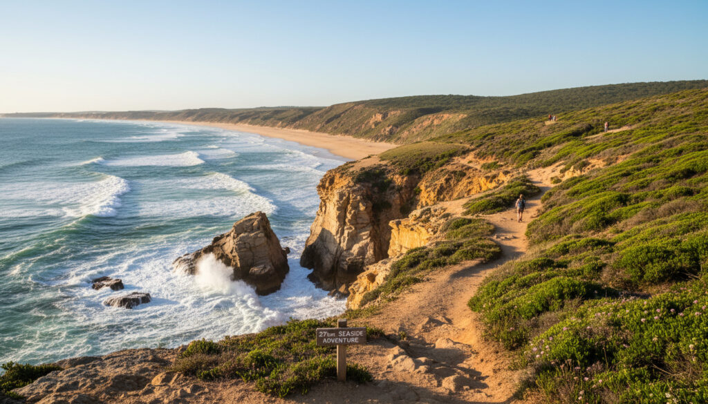
Tomaree Coastal Walk – Complete 27km Trail Guide
The Tomaree Coastal Walk spans 27 kilometres of rugged coastline within Tomaree National Park, linking Shoal Bay to Birubi Point near Anna Bay. Traversing one of New South Wales’ designated Great Walks, the track winds through ancient volcanic headlands, past World War II military installations, and along ten distinct beaches including the clothing-optional Samurai Beach and the expansive Worimi Conservation Lands.
Designed as a multi-day experience, the walk typically requires two days to complete, though fit walkers may finish in less time. The route demands Grade 4 bushwalking capability, with sections of steep ascent, uneven rock platforms, and soft sand testing endurance. Starting from Tomaree Head overlooking Port Stephens, the trail delivers panoramic ocean views before descending to coastal villages that offer resupply points and accommodation.
Beyond the physical challenge, the walk serves as a corridor through Worimi Country, revealing Aboriginal cultural sites alongside 1940s military heritage. Whales migrate past these headlands between May and November, while dolphins regularly patrol the shoreline below. The track accommodates various entry and exit points, allowing walkers to tailor shorter day trips from the full coastal traverse.
How Long is the Tomaree Coastal Walk and What is Its Difficulty?
Officially measured at 27 kilometres, the Tomaree Coastal Walk represents a significant undertaking for experienced hikers. NSW National Parks classifies the route as Grade 4, indicating that prior bushwalking experience proves essential for safe completion. The terrain combines management trails with narrow coastal tracks, sandy beaches, and exposed rock shelves that become hazardous during high tide.
Key practical considerations for planning:
- The standard itinerary divides the walk into an 18-kilometre first day from Shoal Bay to One Mile Beach, followed by a 9-kilometre second day to Birubi Point.
- Shorter alternatives exist, including the demanding Tomaree Head Summit track (2.2 km return, Grade 5) which requires 1.5 to 2 hours.
- While mostly following gentle coastal contours, the route includes short, steep ascents around headlands that elevate heart rates significantly.
- Sandy beach sections slow progress considerably compared to firm trail surfaces.
- A ranger-guided tour option covers selected highlights in two hours, operating from 9:30 am to 11:30 am.
- Three days allows a leisurely pace with extended time for photography and swimming.
- Summer heat and crowds make cooler months the preferred season for undertaking the full traverse.
| Attribute | Specification |
|---|---|
| Total Length | 27 km |
| Difficulty Classification | Grade 4 (Bushwalking experience recommended) |
| Day 1 Distance | 18 km (Shoal Bay to One Mile Beach) |
| Day 2 Distance | 9 km (One Mile Beach to Birubi Point) |
| Summit Alternative | 2.2 km return, Grade 5, 1.5–2 hours |
| Start Point | Tomaree Head, Shoal Bay |
| End Point | Birubi Point, Anna Bay |
| Drive Time from Sydney | 3 hours |
| Guided Tour Duration | 2 hours |
| Available Access Points | Shoal Bay, Fingal Bay, One Mile Beach, Boat Harbour, Fishermans Bay, Birubi Point, Anna Bay |
Where Does the Tomaree Coastal Walk Start and How to Get There?
The northern terminus sits at Tomaree Head within Shoal Bay, while the southern conclusion marks Birubi Point near Anna Bay. Most walkers begin at Shoal Bay to position the sun behind them during morning photography and to tackle the longest segment first when legs remain fresh. However, the route functions equally well in reverse, with logistics adjusting accordingly.
Access Points and Parking
Detailed cartography identifies seven primary access points with parking: Shoal Bay (trail start), Fingal Bay, One Mile Beach, Boat Harbour, Fishermans Bay, Birubi Point, and Anna Bay. During summer weekends and holiday periods, these car parks reach capacity by mid-morning. Arriving before 8 am secures a space and provides cooler conditions for initial walking.
Public transport via Port Stephens Coaches Route 130 services both Shoal Bay and Anna Bay, enabling linear walks without vehicle retrieval. Taxis operate within the region, though pre-booking returns from Birubi Point reduces waiting times. The 180-kilometre drive from Sydney takes approximately three hours via the Pacific Highway.
Navigation and Mapping
Signage along the track remains consistent, marking junctions and beach access points clearly. Walkers should download offline maps before departure, as mobile reception drops in valleys and behind headlands. The official visitor guide recommends checking the NPWS app for real-time alerts regarding track closures or maintenance works.
Is the Tomaree Coastal Walk Suitable for Families and Dogs?
Suitability depends entirely on distance and participant capability. The full 27-kilometre Grade 4 traverse exceeds the stamina of most children under twelve, particularly given rock-hopping sections and exposed headland crossings. However, shorter segments offer family-friendly alternatives with manageable distances and village amenities nearby.
Family Considerations
Day-hike options from Shoal Bay to Fingal Bay (7 km) or shorter summit attempts provide appropriate challenges for older children while maintaining safety margins. The koala sanctuary at One Mile Beach adds educational value for families basing themselves in the region. Parents should assess individual fitness levels carefully; the full two-day itinerary involves significant elevation change and uneven surfaces that trip smaller legs.
Pet Policy Restrictions
Trail monitoring data confirms that dogs remain prohibited throughout Tomaree National Park. Only certified assistance animals accompanying disabled walkers receive exemption. While one unsanctioned 547-metre segment technically permits dogs, this short section does not provide legal access to the main coastal trail and Rangers patrol the park regularly.
The official park management plan strictly forbids domestic animals to protect native wildlife including shorebirds and small mammals. Fines apply for non-compliance. Wood fires are similarly prohibited throughout the national park.
What Are the Top Highlights of the Tomaree Coastal Walk?
The route compresses diverse coastal experiences into a compact geographic area. From the 161-metre summit of Tomaree Head to the rolling dunes of Worimi Country, the walk delivers constant visual variety across its 27-kilometre length.
Natural Landmarks and Beaches
Ten distinct beaches line the route, ranging from the calm waters of Shoal Bay to the surf breaks at Birubi. Local tourism documentation highlights Zenith Beach and Wreck Beach as particularly scenic, while Samurai Beach operates as a legal clothing-optional area requiring respectful conduct. The Worimi Conservation Lands contain the southern hemisphere’s largest mobile sand dunes, creating Saharan landscapes against the Pacific Ocean.
Wildlife encounters punctuate the journey. Humpback and southern right whales migrate past these headlands between May and November. Bottlenose dolphins hunt the shallows year-round, while white-bellied sea eagles soar on thermals above the cliffs. Angophora forests provide shade on inland trail sections, their red bark glowing at sunset.
Military Heritage and Cultural Sites
Tomaree Head hosts well-preserved World War II fortifications including gun emplacements and torpedo tubes installed in 1942 to defend against potential Japanese naval incursions. Interpretive signage explains the strategic importance of Port Stephens during the Pacific War. The landscape itself holds deeper history as Worimi Country, with indigenous cultural sites present though not publicly marked to prevent vandalism.
The summit platform at 161 metres elevation offers the walk’s premier sunrise location. Early morning light illuminates the coastline from Shoal Bay to Port Stephens entrance. Low tide reveals rock pools at Fingal Bay and exposes the full width of sand flats at One Mile Beach.
How Has the Tomaree Coastal Walk Developed Over Time?
The track traverses landscapes shaped by volcanic activity thousands of years ago, recently militarised for coastal defense, and now preserved for conservation and recreation.
- Ancient Formation: The headlands consist of volcanic rock formed millions of years ago, creating the dramatic cliffs and offshore islands visible today.
- Worimi Custodianship: For millennia, the Worimi people managed these coastal resources, leaving cultural sites and traditional pathways that influenced modern track alignment.
- 1942 Military Construction: Australian defense forces installed gun emplacements, torpedo tubes, and radar stations on Tomaree Head following Japanese submarine attacks along the east coast.
- 1970s Park Establishment: Tomaree National Park received formal gazettal, protecting the coastal strip from development and initiating track maintenance programs.
- Great Walks Classification: Recognition as one of NSW Great Walks elevated the trail’s profile, necessitating improved signage and facilities to manage increased visitation.
What Information Remains Variable or Uncertain?
While core trail specifications are established, certain conditions require real-time verification before departure.
| Established Facts | Variable Conditions |
|---|---|
| Exact 27 km length verified by GPS survey | Completion time varies 6–10 hours depending on fitness and photography stops |
| Grade 4 classification fixed by NSW National Parks | Track closures occur during extreme weather or bushfire danger |
| Dogs strictly prohibited (assistance animals excepted) | Water quality and safety conditions at beaches change daily |
| No camping permitted within park boundaries | Tide times determine accessibility of rock platform sections |
| Seven official access points with parking | Mobile phone reception unavailable in several valleys |
Where is the Tomaree Coastal Walk Located?
The trail sits entirely within the Port Stephens local government area on the mid-north coast of New South Wales, approximately 200 kilometres north of Sydney. Unlike the Where Is Home and Away Filmed – Palm Beach Locations Guide which highlights metropolitan Sydney filming locations, this walk offers a more remote coastal experience within the protected boundaries of Tomaree National Park.
Geographically, the route separates Port Stephens inlet from the open Pacific Ocean, running parallel to the coastline along headlands that rise sharply from the sea. The landscape transitions from subtropical littoral rainforest to exposed heathland as walkers progress southward toward the extensive dune systems near Anna Bay. This positioning creates a biodiversity corridor where terrestrial and marine ecosystems intersect.
What Do Official Sources Say About the Trail?
Authority documentation emphasizes both the rewards and requirements of this coastal traverse.
The Tomaree Coastal Walk is a 27 km multi-day coastal trail (Grade 4 difficulty) in Tomaree National Park, Port Stephens, NSW, starting at Tomaree Head in Shoal Bay and ending at Birubi Point near Anna Bay.
— NSW National Parks and Wildlife Service
Some bushwalking experience recommended due to length; mostly flat/gentle with short steep hills, sandy beaches, and rock platforms.
— Official Trail Documentation
Is the Tomaree Coastal Walk Worth Doing?
For walkers possessing appropriate fitness and equipment, the Tomaree Coastal Walk delivers one of New South Wales’ most comprehensive coastal experiences, combining military history, Aboriginal heritage, and dramatic geological features across a manageable multi-day itinerary. The Tomaree Coastal Walk – Complete Guide to 27km Multi-Day Trail provides additional detail for those planning this journey. The trail rewards preparation with solitude, scenery, and a tangible sense of traversing a landscape that has served both as defensive position and spiritual place for generations.
Frequently Asked Questions
Are there facilities on the Tomaree Coastal Walk?
Toilets, lookouts, and information signs exist at key points including Shoal Bay, Fingal Bay, and One Mile Beach. No camping is permitted within the national park, though nearby villages offer accommodation.
Can you do the Tomaree Coastal Walk backwards?
Yes, starting from Birubi Point and finishing at Shoal Bay is possible, though transport logistics differ. Most hikers prefer the northerly start to position the sun favourably for morning photography.
What is the best time to do the Tomaree Coastal Walk?
Cooler months provide optimal conditions, avoiding summer heat and crowds. Whale migration season between May and November offers additional wildlife viewing opportunities. Always check tide charts before departure.
Is the walk free to enter?
Entry to Tomaree National Park is free. No park fees or permits are required to access the Tomaree Coastal Walk. Parking at access points is also free.
Are there drinking water stations along the route?
No reliable drinking water sources exist along the trail. Walkers must carry sufficient water, recommending two litres per person per day, particularly during warm weather.
What footwear is recommended?
Sturdy hiking boots with ankle support handle the rock platforms and steep sections safely. Sand shoes suffice for beach segments but provide insufficient protection on rocky headlands.
More related posts
 Olanzapine Side Effects – Common, Serious and Long-Term Risks
 Noah Schnapp: Relationship, Sexuality, and Why He Stopped Acting
 Chadwick Boseman: Colon Cancer, Death & Legacy
 John McAfee: Death, Net Worth, and Controversy
 Cairns Airport Parking – Rates, Options and Booking Guide
 Farrah Abraham: Life After Teen Mom, Net Worth & More
 Dylan Sprouse: Biography, Net Worth, and Marriage
 Best Clubs Near Me in Dublin & Cork: Nightlife Guide for Over 40s